Distance Calculator

Autoroute du Soleil, La Languedocienne

322.3 km, 3 h 36 min

Head southeast on Rue Pointe Cadet200 m
Turn left onto Rue du Bois70 m
Continue onto Place Chavanelle200 m
Continue onto Rue Étienne Mimard600 m
Turn right onto Rue des Alliés (D 88.1)600 m
Make a slight left onto Boulevard du 38e Régiment d'Infanterie450 m
Turn right onto Rue de la Montat900 m
Enter Rond-Point Antoine Pinay and take the 2nd exit onto N 48850 m
Exit the traffic circle onto N 488900 m
Go straight onto N 4881.5 km
Merge right onto N 886 km
Continue towards St Chamond - Stelytec30 km
Keep right towards A 7: Vienne700 m
Merge left onto Autoroute du Soleil (A 7)200 km
Keep right towards Roquemaure90 km
Keep right onto A 70915 km
Take the ramp towards Montpellier-Sud450 m
Go straight onto M 986150 m
Keep left onto M 98645 m
Enter Rond-Point des Prés d'Arènes and take the 2nd exit onto Rue de l'Abrivado100 m
Exit the traffic circle onto Rue de l'Abrivado350 m
Continue onto Avenue des Prés d'Arènes1 km
Continue onto Avenue de la Liberté1.5 km
Make a slight right onto Rue Adam de Craponne300 m
Continue onto Place Roger Salengro150 m
Turn right onto Rue Daru200 m
Turn right to stay on Rue du Faubourg du Courreau80 m
Continue left onto Rue de la Merci350 m
Turn right onto Rue Foch350 m
Make a U-turn and continue on Rue Foch10 m
Turn right onto Place des Martyrs de la Résistance60 m
Turn left onto Place du Marché aux Fleurs35 m
You have arrived at your destination, straight ahead0 m
From
    To

      Distance: 128.45 mi (206.73 km)

      Driving route: 200.29 mi (322.34 km).

      Driving time: 3h 35 min

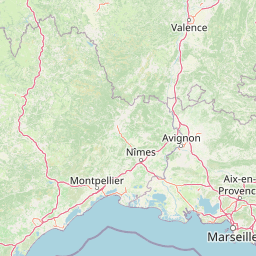
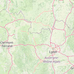
      Distance from Saint-Etienne to Montpellier

      The shortest distance (air line) between Saint-Etienne and Montpellier is 128.45mi (206.73 km)

      The shortest route between Saint-Etienne and Montpellier is 200.29 mi (322.34 km) according to the route planner. The driving time is approx. 3 h 35 m

      How far is it between Saint-Etienne and Montpellier.

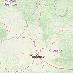
      Saint-Etienne is located in Loire, Francecountry within 45° 26' 4.92" N 4° 23' 25.08" E (45.4347, 4.3903) coordinates. The local time in Saint-Etienne is 14:19 (22.03.2025)

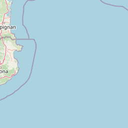
      Montpellier is located in Herault, Francecountry within 43° 36' 42.84" N 3° 52' 37.92" E (43.6119, 3.8772) coordinates. The local time in Montpellier is 14:19 (22.03.2025)

      The calculated flying distance from Saint-Etienne to Montpellier is 128.45miles which is equal to 206.73 km.

      If you want to go by car, the driving driving distance between Saint-Etienne and Montpellier is 200.29 miles (322.34 km). If you ride your car with an average speef of 112 kilometers/hour (70 miles/h), travel time will be 2 hours 53 minutes.Please check the avg.speed travel time on the right for various options

      Estimated Travel Time Between Saint-Etienne and Montpellier

      Average speedTravel Time
      30 mph (48 km/h)6 hours 41 minutes
      40 mph (64 km/h)5 hours 0 minutes
      50 mph (80 km/h)4 hours 0 minutes
      60 mph (67 km/h)3 hours 20 minutes
      70 mph (112 km/h)2 hours 52 minutes
      75 mph (120 km/h)2 hours 40 minutes

      Saint-Etienne, Loire, France

      Related Distances from Saint-Etienne

      CitiesDistance
      Saint-Etienne to Lyon31.27 mi (50.32 km)
      Saint-Etienne to Villeurbanne32.97 mi (53.07 km)
      Saint-Etienne to Grenoble67.24 mi (108.21 km)
      Saint-Etienne to Clermont-Ferrand67.64 mi (108.86 km)
      Saint-Etienne to Nimes110.33 mi (177.56 km)
      Saint-Etienne to Montpellier128.45 mi (206.73 km)
      Saint-Etienne to Dijon133.42 mi (214.71 km)
      Saint-Etienne to Aix-en-Provence141.74 mi (228.11 km)
      Saint-Etienne to Marseille155.46 mi (250.19 km)
      Saint-Etienne to Toulon176.78 mi (284.50 km)
      Saint-Etienne to Nice185.31 mi (298.23 km)
      Saint-Etienne to Toulouse192.48 mi (309.77 km)
      Saint-Etienne to Tours222.22 mi (357.63 km)
      Saint-Etienne to Bordeaux245.67 mi (395.36 km)
      Saint-Etienne to Paris255.07 mi (410.50 km)
      Saint-Etienne to Boulogne-Billancourt255.72 mi (411.55 km)
      Saint-Etienne to Reims265.02 mi (426.51 km)
      Saint-Etienne to Le Mans266.44 mi (428.80 km)
      Saint-Etienne to Strasbourg268.86 mi (432.69 km)
      Saint-Etienne to Angers274.22 mi (441.32 km)
      Saint-Etienne to Nantes309.07 mi (497.40 km)
      Saint-Etienne to Rennes341.58 mi (549.71 km)
      Saint-Etienne to Le Havre344.36 mi (554.20 km)
      Saint-Etienne to Lille364.03 mi (585.85 km)
      Saint-Etienne to Brest465.85 mi (749.71 km)

      Montpellier, Herault, France

      Related Distances to Montpellier

      CitiesDistance
      Nimes to Montpellier28.77 mi (46.30 km)
      Marseille to Montpellier77.98 mi (125.50 km)
      Aix-en-Provence to Montpellier78.73 mi (126.70 km)
      Toulon to Montpellier108.46 mi (174.56 km)
      Toulouse to Montpellier121.73 mi (195.90 km)
      Saint-Etienne to Montpellier128.45 mi (206.73 km)
      Grenoble to Montpellier141.10 mi (227.08 km)
      Clermont-Ferrand to Montpellier155.01 mi (249.46 km)
      Lyon to Montpellier155.77 mi (250.69 km)
      Villeurbanne to Montpellier156.82 mi (252.38 km)
      Nice to Montpellier169.52 mi (272.81 km)
      Bordeaux to Montpellier236.40 mi (380.44 km)
      Dijon to Montpellier261.86 mi (421.42 km)
      Tours to Montpellier303.43 mi (488.32 km)
      Angers to Montpellier342.19 mi (550.70 km)
      Le Mans to Montpellier351.52 mi (565.72 km)
      Nantes to Montpellier362.38 mi (583.20 km)
      Boulogne-Billancourt to Montpellier369.25 mi (594.25 km)
      Paris to Montpellier369.62 mi (594.84 km)
      Strasbourg to Montpellier390.18 mi (627.94 km)
      Reims to Montpellier390.51 mi (628.47 km)
      Rennes to Montpellier409.98 mi (659.81 km)
      Le Havre to Montpellier443.88 mi (714.36 km)
      Lille to Montpellier486.27 mi (782.58 km)
      Brest to Montpellier519.34 mi (835.80 km)